 |
UK Broadcast Transmission |
        |
|
    |
|


 |
|
|
 |
||||||||
 |
|||||||||||
| SELF HELP RELAYS |
| A guide to finding 'Challenge Sites' |
| © John Martin |
Eilean Mor Self Help |
The Hit List |
|
mb21 has a list of about 180 Challenge Sites, the majority of which were community-funded, self-help, analogue UHF TV relays. They are challenges because of the lack of available information, imprecise location details, difficulty of access or because many of them simply may no longer exist. I am writing this in 2022, the one-hundredth anniversary year of the BBC, so paying tribute to these humble but important examples of broadcasting history is timely. If you like detective work and a pleasant afternoon in the countryside, finding these sites can be very rewarding indeed. But simply tapping the location into your Satnav and heading off with a camera is probably the last thing you should do, as your journey might be wasted. So we offer some suggestions, based on experience, to make your hunting more successful. |
|
Some Background |
|
The final phase of the broadcasters' UHF TV relay building programme, Phase III, was limited to population groups of as few as 200 people where this proved to be economic and practicable. (See pages 64-65 of the BBC Annual Report and Handbook 1982.) This left many smaller communities either poorly served, or completely without any usable signal. Consequently the pressure for self-help relays grew in those smaller communities. Self-help relays were first licensed in 1980. There are various stories about which was first but it is thought to be the community of Acharacle in Ardnamurchan, Scotland. Apparently, this was achieved by the local butcher challenging the Home Office policy of the time. The broadcasters were supportive of community relays and would often assist with the necessary post-installation checks of power output, coverage area and for the required suppression of harmonic and spurious radiation which might cause interference to other services. Charles Hope, a regular contributor to mb21, was someone who gave advice to communities on planning and location of self-help relays. He recalls that installation was often done by local domestic aerial riggers. Charles, and others, would then carry out the post-installation commissioning approvals. Licensing was administered by The Radiocommunications Agency of the Department of Trade and Industry (the then equivalent of Ofcom), while the BBC or IBA specified the basic operating characteristics like channel allocations, transmitter powers and possible aerial sites. There is evidence that illegal relays existed well before 1980. The Summer 1980 edition of the BBC Engineering magazine Eng Inf has more information. All the relays, about which we have some information, are UHF and licensed for four channels with ERPs of 1-5 Watts, although there are a few as high as 20W. These relays started to fall out of use around the turn of the century when the 4 main TV channels became available via digital satellite and further declined as a result of Digital Switchover (DSO). In many cases the redundant equipment would have been removed by the community but a lot still remains to be found. It would be wrong to give the impression that self-helps are entirely artefacts of the past. Since DSO, there have been more than a dozen new digital self-help licences issued by Ofcom. Often located to serve caravan parks, these new sites are worth a visit too, as some of them are yet to be photographed for mb21. As always, the mb21 Hit List is your starting point. |
|
Two Types of Relay |
|
The most simple form of relay is the Active Deflector (AD) which consists of a receive aerial, a series of amplifiers and possibly filters, followed by a power output module and one or more transmit aerials (Fig.1). Physical isolation between Tx and Rx aerials was necessary to prevent feedback leading to the catastrophic build-up of spurious interfering signals. This was achieved by physical distancing - often 100m or more, the use of directional aerials and, when possible, by the use of different aerial polarisations for the Tx and Rx. Some AD systems used channel-specific receiving and transmitting modules but others seem to be wide-band or filtered for a group of channels. The publication BBC Engineering 89 provides details of the active deflector installation at Bethesda, which was the first UHF AD relay built. |

|
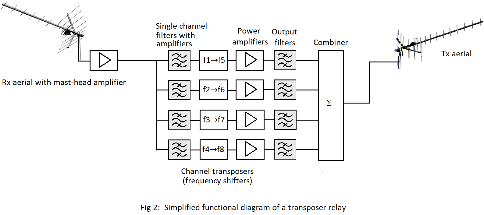
The other type of relay is the Transposer (T or TP) which receives one set of channels from its parent station then converts them into a set of different channel frequencies before amplifying and transmitting them (Fig.2). Shifting the frequencies not only satisfies the need for spectrum management but also helps to overcome the possibility of feedback. This allows for easier positioning of Tx and Rx aerials which are often on the same mast. |
 |
|
This is an example of a Transposer self-help relay using a single mast. |
 |
|
While the aerials used are clearly domestic varieties to save cost, the electronics behind them tend to be commercial. Although the construction of an analogue relay system was well within the capabilities of a radio amateur or electronics enthusiast - and some of the early illegal installations were probably home-made - one commercial supplier of equipment for many of these self-helps was Taylor Bros. of Oldham (now TX Systems). A complete 4-channel transposer system was listed in their 2003 catalogue with a total cost of about £2,500 which equates to something over £4,500 in today's money. Permission has kindly been given to include that catalogue page here: |
 UHF Transposer diagram - courtesy Taylor Bros. of Oldham 1980 catalogue |
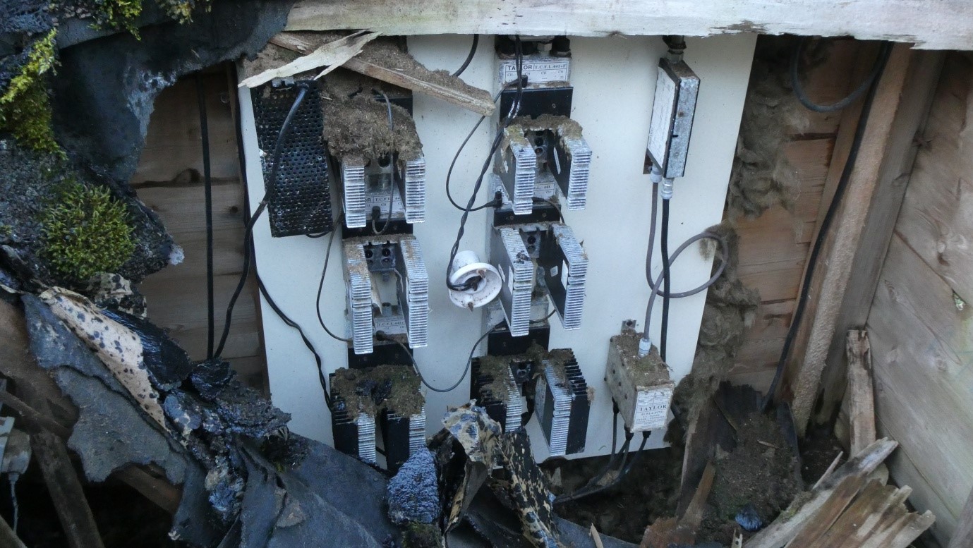
When finding these old relay sites, it is very rewarding if the equipment is still in place, as at this site in Dalwhinnie, Perthshire: |
 Dalwhinnie Self Help |
Locations |
|
The mb21 Hit List and Ofcom's information include National Grid References for these schemes, but they are generally inaccurate and sometimes conflicting. Often they simply indicate the location of the community which the relay served, rather than the location of the equipment itself, which can often be 1-2km from that community. That means that the Tx and Rx equipment could lie anywhere within an area of about 12km2 around the given location. That is a large area to search and the reason why jumping straight into your car with a camera might prove to be a wasted journey. So we offer the following detective tools to assist your search.
|
Is Google your Friend? |
|
It is certainly worth using Google searches, Google Maps, satellite imagery, Google Earth and Street View before you leave the house. Be warned, though, that using Street View for an area of 12km2 can take a long time and is useless away from roads. Street View, though, can have some advantages because some of the photography was taken as far back as 2008. The Winterton-on-Sea self-help appears in a July 2009 Street View image, but the aerials have gone by the May 2011 image. Satellite imaging can produce results if you know what you are looking for and have an educated idea as to where the relay might be. But results are often disappointing: the smaller installations are often only a few pixels in size. |
Dalwhinnie Self Help : an example of the TX part of a split AD transposer |
Eilean Mor Self Help |
Local Knowledge |
|
If you are unfamiliar with the area you propose to visit, try and make email contact with someone who is. Suggestions include:
This has produced amazing results. I had an excellent response from the Chair of the Community Council in one location. The Chair put out the request for information on the community's FaceBook page and was flooded with personal accounts of the relay from several local residents. If the email is clear about what you are doing and why, it can produce some very interesting information from enthusiastic locals who may well have personal recollections about the relay and can help you locate the sites of the installations. There really is no substitute for local knowledge. |
|
Mapping Skills |
|
Gazing at a good OS map might help to identify geographical features which would indicate likely spots for relays: tops of hills or ridges etc. Bing has an excellent online OS map facility with the ability to switch between OS, roadmaps and satellite views. Another very useful tool is an online terrain-mapping utility like Solwise which allows you to drop a pin on a map at the location of the parent station of your relay scheme and add in the mast height. Another pin can be moved around your potential relay site, giving you a plot of the intervening mountains and helping you decide where line-of-sight reception paths are possible. (See Solwise plot below). However, sometimes you may find that the actual site does not have LOS to the parent station but yet managed to work. The laws of physics are not broken, but effects like diffraction, reflection and the dreaded Fresnel Zones come into play and help to mitigate the laws. |
Example of the Solwise elevation tool used to map the path between Rosemarkie and Dalwhinnie. |
|
Preparing for The Site Visit |
|
Armed with some information in advance, it is time to head out in the car. If the location is very rural, you might want to consider a 4x4 or horse as transport. Many locations might only be accessible on foot and after climbing over electrified barbed wire! Take binoculars, camera, walking shoes, wellies, food and drink, a map and compass, pen and paper. A drone equipped with a good camera can help you see above the trees which may not have been there at the time of installation. If you are really keen, take a portable signal analyser and log-periodic on a pole. If you find an old relay, it is highly unlikely to be working but using a signal analyser to assess the viability of Rx sites can be useful. A small, portable and cheap but excellent addition to your toolbox should be the TinySA spectrum analyser and it is 25 times cheaper than an entry-level ProMax. |
|
On the Ground |
|
|
| Further reading : A detailed description of the Redbrook Self-Help relay was published in the February 1982 edition of Wireless World from page 71 |
|